North Shore anticipating winters return with heavy snow and wind starting Sunday evening
A significant winter storm is expected to arrive along the North Shore starting Sunday evening.
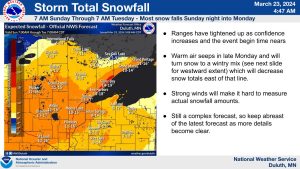
On Mar. 23, the National Weather Service issued a blizzard warning for Lake and Cook County from Sunday afternoon through Tuesday morning.
The blizzard warning calls for snow accumulations totaling 14 to 19 inches in Cook County. Accompanying the high snow amounts will be 55 mph wind gusts.
“This is going to be a pretty big system. It’s going to impact travel. Especially if you’re driving along the North Shore,” Ketzel Levens, a National Weather Service meteorologist, told WTIP on Mar. 21. She said to prepare for blizzard and lake-effect snow conditions.
The National Weather Service blizzard warning states, “Strong winds could cause extensive damage to trees and power lines.”
While the National Weather Service estimates significant amounts of snow, Levens told WTIP that temperatures will hover at or above freezing closer to the Lake Superior shore on Monday, creating more potential for mixed precipitation. “There may be some mixed precipitation on Monday during the day since we do warm up to around near freezing, especially near the shore.”

WTIP’s CJ Heithoff spoke with Ketzel Levens, a National Weather Service meteorologist on Mar. 21 for a winter storm weekend outlook. Audio from the interview is below.
Listen to 90.7 FM for current conditions and additional weather-related news and information.
Kalli Hawkins March 23, 2024