Reports of up to 4 inches of precipitation received along the North Shore
Storms and showers moved across the Midwest and northern Minnesota on Monday, May 21, and into the morning on Tuesday, May 22, bringing significant amounts of precipitation.
Many North Shore and northern Minnesota areas received approximately 1 to 4 inches of precipitation in the last 24 hours.
According to CoCoRaHS data, a volunteer network of weather observers, precipitation amounts varied considerably across Cook County. Precipitation amounts closer to the Lake Superior shore range from 2.35 to 2.83 inches. In comparison, rainfall amounts farther inland within the Superior National Forest and Boundary Waters Canoe Area Wilderness range from 1.80 to 2.16 inches.
Farther down the shore in Lake County, CoCoRaHS data shows precipitation reports of 1.83 to 3.44 inches.
“The North Shore was one of the big winners,” Ketzel Levens, a meteorologist with the National Weather Service said in an interview with WTIP on Wednesday morning. “We saw a lot of rain get dropped.”
The following precipitation totals from WTIP listeners as of 8 a.m. on May 22 are below.
- Hovland – 4 inches
- North of Highway 61 about a mile west of Hovland – Just under 3 inches
- Grand Portage – 3.75 inches
- County Road 7 – 2.5 inches
- Grand Marais – 2 inches
- Old Ski Hill Road– 2.43 inches
- Lutsen – 1 inch
- Caribou Lake – 2.54 inches
- North of Caribou Lake – 3.5 inches
- Silver Bay – 3.44 inches
- Lutsen – 2.75 inches
- Mid-Good Harbor Hill – 2.6 inches
Call WTIP at 218-387-1070 to share your precipitation totals!
Rain will continue to move through the northern Minnesota region on Wednesday, May 22, creating elevated river and creek levels, the National Weather Service said. Scattered showers and thunderstorms are expected to develop again this afternoon and evening. However, severe storms are not expected.
As Memorial Weekend approaches, Levens said “Our wet pattern isn’t quite over.” More rain and showers are expected Friday, May 24 and Saturday, May 25.
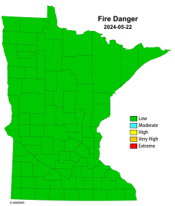
With the recent precipitation, the Minnesota Department of Natural Resources updated the fire danger for May 22. The current fire danger is low for the entire state of Minnesota.
Kalli Hawkins May 22, 2024