Canadian wildfires blanket northern Minnesota in smoke, air quality alerts in effect
Over the weekend, smoke from Canadian wildfires continued to blanket Minnesota and the North Shore of Lake Superior, prompting updated air quality alerts.
The Minnesota Pollution Control Agency issued air quality alerts, with forecasts predicting cleaner air on Monday, July 14.
However, on Monday afternoon, the MPCA issued another alert after meteorologists determined that wind conditions would cause existing wildfire smoke in northern Minnesota to linger.
“Concentrations are expected to be highest along and near the shores of Lake Superior,” the MPCA alert said. The new air quality alert is in effect as of 3 p.m. and will remain in place until 11 p.m. on Tuesday, July 15.
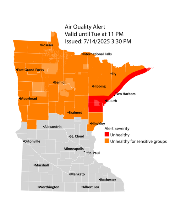 The MPCA stated that visitors and residents of northern Minnesota can expect continued heavy smoke conditions as “an additional round of heavy smoke from wildfires across southern Canada is expected to transport into northern Minnesota on Tuesday.”
Fine particle levels are expected to reach the red air quality index (AQI) category along the North Shore, a level considered unhealthy. This area includes Grand Marais, Two Harbors, Duluth, and the Tribal Nations of Grand Portage and Fond du Lac. The MPCA advises individuals in the red area to avoid prolonged or heavy exertion and limit their time spent outdoors.
“If you’re someone who deals with any heart or lung problems, best to stay inside,” Ketzel Levens, a meteorologist with the National Weather Service in Duluth told WTIP on Monday.
According to the MPCA, unhealthy AQI levels may create symptoms such as irritated eyes, nose, and throat, coughing, chest tightness, or shortness of breath. Sensitive or more exposed individuals may experience more serious health effects, including worsening of existing heart or lung disease and respiratory and cardiovascular conditions, possibly leading to an asthma attack, heart attack, or stroke.
Fires in Canada prompt state of emergency for some
All of Manitoba is under a state of emergency due to the wildfires, which have led to the evacuation of 12,600 people from their homes in the province. The fires in the central Canadian province have burned over 3,861 square miles, the most land burned in 30 years of electronic record-keeping.
Under 1,000 people have evacuated their homes in Saskatchewan, where wildfires also continue to burn. As of July 9, the National Wildland Fire Situation Report states that the Lower Fishing Lake Fire in Saskatchewan has burned over 1.3 million acres and remains out of control. Narrow Hills Provincial Park and the East Trout-Nipekamew Lakes Recreation Site remain closed due to the wildfire activity.
Canada is at a National Preparedness Level 5, which fire officials indicate requires a full commitment of national resources and an extreme demand for interagency resources through the Canadian Interagency Forest Fire Center (CIFFC).
The CIFFC said in a July 9 fire report, the number of Canadian wildfires is average for this time of year; however, the area burned to date is significantly more than the 10-year average. So far in 2025, there have been 2,962 wildfires in Canada, burning a total of 11,515.041 acres.
The 10-year average to date is 2,961, with a total of 4,224,345 acres burned.
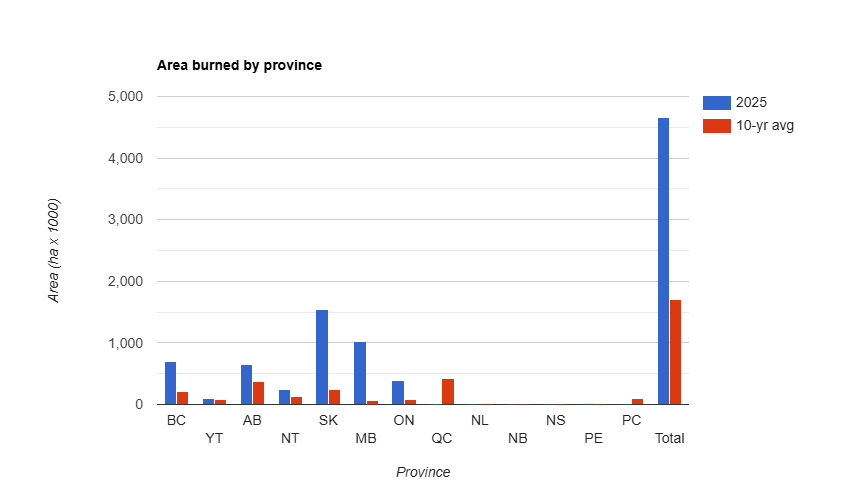
Area burned (in hectares) by Canadian Province
Kalli Hawkins July 14, 2025