Firearm deer season begins in two weeks, Arrowhead archery harvest remains low
More than a month into Minnesota’s archery deer season, harvest numbers across the Arrowhead region remain low, according to the latest reports from the Minnesota Department of Natural Resources (DNR).
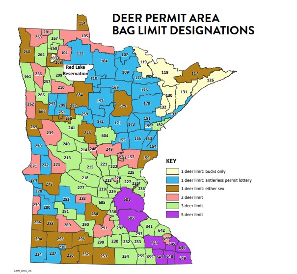
The northeast region, commonly called the Superior Uplands–Arrowhead region, includes Cook and Lake counties and is divided into six deer permit areas (DPAs): 117, 118, 126, 130, 131, and 133.
As of Oct. 22, hunters have harvested three bucks and two does during the archery season in DPA 126, which encompasses most of Cook County. The archery season began on Sept. 19.
The DNR designated DPA 126 as bucks-only for the 2026 season, meaning hunters cannot harvest a doe during the season. The bucks-only designation has been in place across much of the Superior Upland-Arrowhead region for several years as a conservative management practice due to continued low deer populations. However, there are a couple of provisions to the bucks-only rule.
The DNR allows hunters who live in a Minnesota Veterans Home or are 84 or older to harvest an antlerless deer (doe). Nancy Hanson, the DNR’s Two Harbors area wildlife manager, said hunters have harvested does in the bucks-only deer permit area under this provision in the past couple of years. Hanson said the two does registered in DPA 126 this season likely have been harvested under this provision, though the DNR will investigate to confirm.
Within Minnesota State Parks, including Cascade State Park and Judge C.R. Magney State Park, the DNR also allows a limited number of lottery permits for hunters to harvest a buck or a doe during the firearm season.
In neighboring DPA 117, which encompasses a large portion of the Boundary Waters Canoe Area Wilderness and is designated as either sex, there are two registered harvested does as of Oct. 22. In DPA 118, which includes Ely and the western edges of the Superior National Forest, nine deer have been harvested.
Along the North Shore, in DPA 131, one buck has been harvested, and in DPA 130, three deer have been harvested. Closer to Two Harbors and along the Lake Superior shore, DPA 133, which typically has a higher deer density and population, has 28 deer harvested.
Graphic by the Minnesota DNR
Archery season gives hunters a chance to get into the woods before the firearm season and the peak of the deer rut, which typically occurs in late October or early November. Archery hunters generally harvest fewer deer than firearm hunters.
Hunters will take to the woods in two weeks for the annual firearm deer season opener on Saturday, Nov. 7. The season runs through Nov. 22.
While archery harvest numbers are low in the Arrowhead region, archery season is off to a strong start in other parts of the state.
So far, across the state, hunters have harvested 25,282 deer during Minnesota’s archery season. A large portion is concentrated in the western and southwest regions, where deer populations are higher.
Looking at last year’s harvest numbers, Minnesota hunters harvested a record 30,043 deer during the 2025 archery season. Crossbows and vertical bows each accounted for roughly half of the total harvest, according to the DNR. Archery season remains open until Dec. 31.
The 2026 deer hunting season marks the start of a new statewide chronic wasting disease (CWD) surveillance plan. The DNR is expanding its approach to monitoring CWD and implementing mandatory testing for CWD for deer harvested during firearms opening weekend that are one year old or older.
The mandatory testing schedule begins in southwest Minnesota in 2026, then moves to northwest Minnesota in 2027, northeast Minnesota in 2028, and southeast Minnesota in 2029.
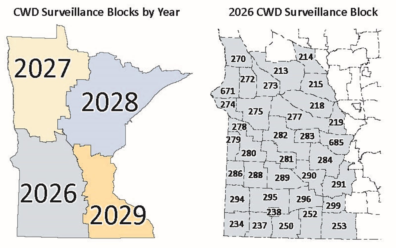
Graphic by the Minnesota DNR
CWD is a fatal neurological disease that affects deer, elk, and other members of the cervid family. The disease has been prevalent in various cervid species across the U.S. and other countries since the 1960s. It is caused by abnormal proteins called prions.
CWD has been detected in parts of Minnesota, including central and southern Minnesota, but the northeast Arrowhead region has had no confirmed cases.
Although CWD testing will be mandatory only in the southwest quadrant for the upcoming 2026 deer hunting season, the DNR offers several free, convenient ways for hunters to get their deer tested statewide. Hunters can order a mail-in kit prior to opening weekend, visit a staffed or self-service sampling station, or visit a taxidermist participating in the partner sampling program.
As more hunters take to the field, the DNR invites deer hunters to report any wildlife sightings while in the woods. These observations help the DNR estimate population-level trends for deer and track wildlife distribution for other species across the state. Learn more here: https://www.dnr.state.mn.us/mammals/deer/management/hunter-field-log.html
The 2026 Minnesota hunting and trapping regulations are available through the DNR website.
Kalli Hawkins October 24, 2026