Isolated blowdown discovered in areas of BWCA and Superior National Forest
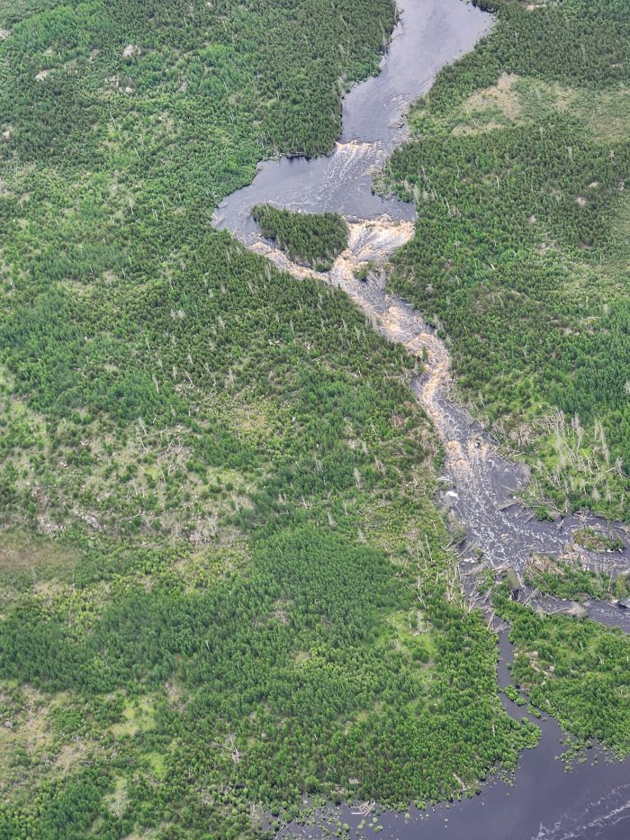
Damage assessments following the June 18 severe weather and flooding continue across northeastern Minnesota.
Over the weekend, the Superior National Forest conducted aerial surveys of the Superior National Forest and the Boundary Waters Canoe Area Wilderness (BWCAW) within the Gunflint and Tofte Districts.
Numerous isolated pockets of moderate to high severity wind-damaged vegetation and blowdown were identified as a result of the recent storm activity.
“Wilderness rangers on the Gunflint Ranger District discovered what they discern as straight-line wind or tornado damage to vegetation in the Boundary Waters Canoe Area Wilderness (BWCAW) on a border route portage,” Christine Kolinski, the public information officer for the Superior National Forest said.
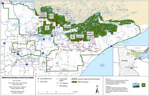
The following blowdown areas were identified:
Blowdown Areas
- The Border Route Trail, BWCAW Entry Points 81-83-Border Route Trail). This area has 10–15-acre pockets from Gunflint Lake heading east.
- Areas north of Greenwood Lake, adjacent to the BWCAW, contains pockets of blow down approximately 10-25 acres in size. Areas are scattered and mostly away from portages.
- Inside the BWCAW, north and east of the Gunflint Trail, significant pockets of blow down are located in the Rose Lake area east towards Mountain Lake.
- The Tofte Ranger District has up-to 50-acre of blow down along the Sawbill Trail and Kawishiwi Lake areas. Windy Lake, Clearwater, and Clara Lake areas also have blowdown acres.
- Temperance River corridor has a lot of pockets of blow down. Currently tree fall is not blocking river access or across the trail, but conditions could change.
- The Lost Lake Road area has 10–20-acre blown down patches.
- The Timber-Frear ATV Trail on the Tofte Ranger District has been heavily impacted with blow down.
Given the flooding and road washout conditions, Forest Service officials closed numerous BWCAW entry points and canceled permits last week due to inaccessibility.
“All visitors at BWCAW entry points that were blocked in by road washouts have been escorted out,” Kolinski said.
BWCAW Entry Point Update
The following BWCAW entry points have been canceled through June 25, 2024:
- Trout Lake Overnight Motor #1
- Trout Lake Day Use Motor Entry Point #A
- Slim Lake Entry Point #6.
- Moose River North Entry Point #16.
- Island River Entry Point #34.
- Isabella Lake Entry Point #35.
- Bog Lake Entry Point #67.
- Pow Wow Trail Entry Point #86.
A current list of BWCAW entry point closures is below:
Kalli Hawkins June 24, 2024