
Canadian wildfire smoke brings slight haze, moderate air quality to Cook County
Residents and visitors across Cook County woke up Tuesday morning to the smell of wildfire smoke and slightly hazy skies, as smoke from Canadian wildfires moves across the northeast region this week.
Air quality in Cook and Lake County is in the moderate range, according to the Minnesota Pollution Control Agency, meaning air quality is generally acceptable for most people, though some individuals who are unusually sensitive to air pollution may experience health effects.
The MPCA tracks air quality using the Air Quality Index, or AQI. The AQI measures pollutants including fine particulate matter, which is the primary concern during wildfire smoke events. Fine particle pollution from wildfire smoke can irritate eyes, nose, and throat, causing coughing, chest tightness, shortness of breath, or dizziness.
The MPCA recommends that unusually sensitive people should consider making outdoor activities light and short and to go indoors if experiencing symptoms.
Moderate air quality conditions due to wildfire smoke moving through the area are expected to continue Tuesday and Wednesday, with conditions improving by Thursday.
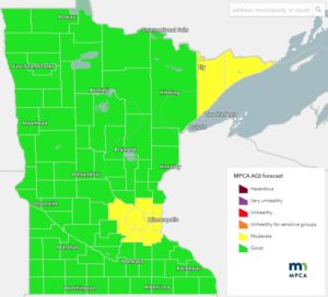
MPCA Air Quality Forecast Map showing moderate air quality conditions for northeast Minnesota for July 7, 2026 | MPCA Graphic
Nearly a dozen wildfires were burning in the Canadian province of Ontario, just north of the U.S./Canada border and within Quetico Provincial Park. On Monday, Canadian officials announced closures and evacuations within the park due to a nearly 2,000-acre wildfire, designated as FOR015.
Quetico Provincial Park officials said conditions will be reassessed on July 10 and will determine if further cancellations are required. The closures include lakes Olifaunt, Fern, Bud, Buckingham, Sturgeon, and stretch north to Pickerel. Olifaunt Lake is approximately 34 miles from Saganaga Lake towards the end of the Gunflint Trail and along the U.S./Canada border. See a map of the closure area below.
Several other areas across the U.S., including Colorado are experiencing several severe wildfires this summer. A wildfire burning southwest of Denver forced the evacuation of thousands of residents and destroyed more than 160 structures by Friday as erratic winds pushed the blaze across two Colorado counties.
The Aspen Acres fire is one of about 40 uncontained large blazes burning mostly in the West, fueled by months of dry weather and a record lack of snow this past winter in some places.
For the latest information and air quality conditions, visit the Minnesota Pollution Control Agency website or Airnow.gov.
Learn more in a recent WTIP interview with Cook County Public Health and Human Services officials about wildfires, smoke, and other summer safety preparedness here.
The Associated Press contributed to this report.
Kalli Hawkins July 7, 2026