Cook County eases Gunflint Trail evacuation status as Little Knife Fire containment grows
The Cook County Sheriff’s Office announced Sunday evening that evacuation zones along the Gunflint Trail will be reduced beginning Monday, July 27, following continued containment of the Little Knife Fire.
The decision comes after a team of hotshot and smokejumper crews was inserted on the ground over the weekend near the Little Knife Fire and after consultation with the U.S. Forest Service and National Incident Management Organization (NIMO), the sheriff’s office said.
As of Sunday evening, the sheriff’s office said containment of the Little Knife Fire is 49%.
Effective Monday, July 27, the Sheriff’s Office will remove all ‘Ready’ evacuation zones in the mid-trail area of the Gunflint Trail, designated as Gunflint Districts 2, 3, and 4.
Towards the end of the Gunflint Trail, the area has been in a ‘Set’ designation. Starting Monday, the evacuation order will be reduced to a ‘Ready,’ reflecting improved conditions.
The sheriff’s office said additional changes will also go into effect on Monday for select areas within the Boundary Waters Canoe Area Wilderness. The ‘Go’ evacuation status for the BWCAW East District will be removed.
The ‘Go’ status for the BWCAW West District will be updated to align with the U.S. Forest Service’s revised map showing portions of the BWCAW in Cook County reopening for day trips beginning Monday, July 27.
The Forest Service announced last week that select BWCAW entry points in Cook County will reopen for day-use only, starting Monday. While day-use access will be allowed at select points of entry, all overnight access will remain closed through Wednesday, July 29. The Forest Service said it will reassess overnight access on July 30, provided no significant wildfire activity occurs.
“While this is an ideal step in the right direction for the Little Knife Fire, we need to caution that weather and fire activity are dynamic,” the sheriff’s office said. “While analysts can make predictions, things can change at any time.”
The Sheriff’s Office said it will continue meeting regularly with NIMO and the Forest Service to monitor conditions and make any necessary adjustments to evacuation areas to help keep Cook County residents and visitors safe.
Residents and visitors are encouraged to stay informed by monitoring official evacuation updates as firefighting efforts continue.
Find the maps and more information on ‘Know Your Zone’ here: https://cookcountymn.maps.arcgis.com/apps/webappviewer/index.html?id=2f0cb0740663455e9fe5c47b7fdb2379&fbclid=IwY2xjawTTaQRwZG9mAWV4dG4DYWVtAjExAHNydGMGYXBwX2lkEDIyMjAzOTE3ODgyMDA4OTIAAR6UhXiEuJyXB259eXUcaTv0gDf0SRFGKSsbkZ_F1R-eekWH-s_JEg3o5q0hOA_aem_50sU6i0baed-pDP8cnMZvw
Learn more emergency evacuation information here: https://cookcountymn.gov/government/departments/emergency_management/emergency_evacuation_reminders.php
See a map below of the BWCAW entry points that will reopen on Monday, July 27 for day-use only in Cook County below:
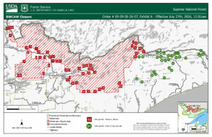
Map of BWCAW entry points in green that will open for day use starting Monday in Cook County | USFS
Kalli Hawkins July 26, 2026