Cook County road reports and rainfall totals, officials monitoring and assessing flood damage
Flash flooding and severe thunderstorm on Tuesday June 18, have caused significant damage across the Superior National Forest and northeastern Minnesota region.
The Cook County Highway Department, Cook County Sheriff’s Office, Superior National Forest officials, and Minnesota Department of Transportation officials are closely monitoring road conditions after the heavy rainstorms yesterday and last night. Superior National Forest staff in all five District Ranger stations are currently assessing the extent of the damage across the 3 million acre forest, specifically at Boundary Waters Canoe Area Wilderness entry points, campgrounds, roads, and trailheads. Damage assessments are expected in the coming days.
The Cook County Highway Department crews are out clearing trees and debris from county roads. “Nothing major to report, which is good news!,” Cook County Highway Engineer Robbie Hass told WTIP. “I would still caution people to stay home unless its an emergency.” As of Wednesday morning, June 19, all major county roads are passable, but there may be small branches and debris on road.
Many WTIP listeners have reported water damage in home basements due to the heavy rainfall.
Road & Trail Reports:
Here is a list of the known road and trail damage reports:
- Culvert plugged in Tofte across from Bluefin Bay on Hwy 61 creating flooding conditions on the Hwy
- Sugarloaf Road is impassable due to a washed out culvert.
- Schroeder Supervisor Tina McKeever said for residents on the north half of the road, “It’s recommended to use Cramer Road to return to Highway 61. They’re working on a temporary fix to make the road passable.”
- Barker Lake Rd near Wild Country Maple Syrup in Lutsen has experienced road washout damage
- The Gitchi-Gami Bike Trail received significant storm damage.
- WTIP listener Greg Lindsey said the bike trail is flooded with 6-8 inches of water where the bike trail passes under Hwy 61 through a box culvert, about 1.5 miles SE of Ski Hill Road in Lutsen. On the north side of Hwy 61, the trail is half-covered in mud and debris.
- Finland Snowmobile/ATV Club reported damage to trails
- Trails are closed until damage assessments are done. “There will be washouts, damaged, or missing bridges,” the club said in a Facebook post. “We will post updates as we get them.”
-
As of 9 a.m. Wednesday June 19, the Minnesota Department of Transportation stated the following highways are closed:
- Highway 1 between Sassas Road and Brown Road (15 miles west of Tower). The road has washed out and a detour is in operation.
- Highway 1 east of Ely (MP 293.7). The road has washed out and a detour is being installed.
- Highway 53 just south of Independence. One southbound lane is closed.
- Highway 61 at Taconite Harbor. One lane is closed and a signal-controlled bypass is in operation.
- Highway 169 between Karjala Road and Koski Road south of Tower. The road is closed.
Call WTIP at 218-387-1070 to share your road observations and reports.
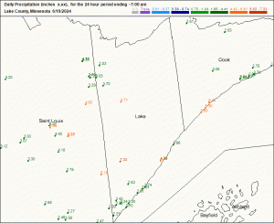
Precipitation totals for Cook County & Northeastern Minnesota:
- County Road 7 – 3.5 inches
- Lutsen – 4.1 inches
- Taconite Harbor – 9 inches
- Hovland – 2.25 inches
- St. Louis County – near Cotton report of 5.20 inches of rain
- Tofte & Schroeder area – 5.30-5.44 inches reported on west end closer to Lake County border
- 20 miles north of Two Harbors – 7.33 inches
- Grand Marais – 2-2.5 inches
- Grand Portage – 1.8 inches
- West Twin Lake – 3.5 inches
CoCoRaHS volunteer precipitation data for Wednesday, June 19 of Cook & Lake Counties is below:
Call WTIP at 218-387-1070 to share your precipitation totals.
WTIP spoke with National Weather Service Meteorologist Woody Unruh on Wednesday, June 19 at 9:10 a.m. about the storm and rainfall totals.
WTIP spoke with Cook County Sheriff Pat Eliasen on Thursday, June 20 at 7:40 a.m. to check in following damage assessments. Audio from the interviews are below.
Kalli Hawkins June 19, 2024