Firefighters continue suppression efforts on seven Superior National Forest wildfires
Fire officials with the Superior National Forest are continuing to monitor and suppress seven wildfires reported on Tuesday and Wednesday. Five of the wildfires were reported on Tuesday, and two additional fires were reported following aerial detections on Wednesday.
Several of the wildfires are within the Boundary Waters Canoe Area Wilderness (BWCAW). Although there are seven active fires, there are no current fire closures in place for the BWCAW.
Fire officials said, however, “The public is asked to stay out of the fire areas for their safety and firefighter safety.”
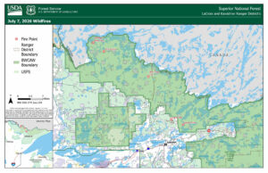
Location of five of the seven wildfires in the Superior National Forest | Contributed U.S. Forest Service
Although there are five active fires, there are no current fire closures in place for the BWCAW. Fire officials said, however, “The public is asked to stay out of the fire areas for their safety and firefighter safety.”
Updates on the five wildfires as of Wednesday at 6 p.m. are below:
Camp Fire
Location: Approximately 8 miles north/northeast of the Cloquet Line near Ely
Size: Estimated 1-2 acres
Cause: Unknown
Status: The fire is burning in heavy dead and downed vegetation. It continues to creep and smolder, with some moderate fire activity observed late yesterday afternoon. Two single-engine float planes supported suppression efforts with multiple water drops. Three firefighters are on scene, and additional personnel will join them to continue direct suppression.
Bear Trap Fire
Location: Off the Bear Trap River and north of Sunday Lake in the BWCAW
Size: Less than an acre (.10-acre)
Cause: Lightning
Status: The fire is burning in a remote part of the BWCAW with very difficult access. It was reported as a single-tree lightning strike with wispy smoke and minimal fire activity. The fire is burning in mixed boreal forest vegetation. Firefighters are strategizing access and suppression options.
Thumb Fire
Location: Between Thumb and Contentment Lake in the BWCAW
Size: Less than an acre (.10-acre)
Cause: Lighting
Status: The fire is burning in a remote portion of the BWCAW with difficult access. It was reported as a single-tree strike with minimal fire activity. Firefighters are strategizing access and suppression options.
Section 3 Pond Fire
Location: On Section Pond, east of Lac La Croix and just south of the Canadian Border in the BWCAW
Size: Less than an acre (.75-acre)
Cause: Unknown
Status: Minimal fire activity has been observed, and firefighters are using a direct extinguishment strategy to reduce fire spread. Two firefighters are currently on scene, and two more are traveling to assist.
Newton Fire
Location: Just west of Newton Lake in the BWCAW
Size: One acre
Cause: Lightning
Status: The fire is a single-tree lightning strike burning in the BWCAW. Two firefighters are on scene conducting direct suppression. Two firefighters are responding to the fire.
The Echo 2 Fire
Location: Off of Echo Rapids Road, north of Echo Lake
Size: Less than an acre (.10-acre)
Cause: Unknown
Status: Discovered on Wednesday afternoon. Firefighting resources are en route.
Fools Gold Fire
Location: West of Norway Road and south of Lake Jeanette
Size: Less than an acre (.5-acre)
Cause: Unknown
Status: Discovered on Wednesday afternoon. Firefighting resources are en route.
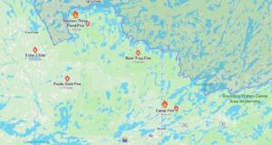
Location of all seven wildfires in the Superior National Forest | Graphic by Watch Duty
Superior National Forest officials said, “Suppression in the BWCAW will use minimum-impact tactics whenever possible.” Firefighters will use natural features, such as lowlands and shorelines, as containment lines, and use hand tools and water bags to cool hot spots when conditions allow.
Updates will be provided as more information is available.
Kalli Hawkins July 8, 2026