Sheriff’s Office raises evacuation designation to ‘Set’ for end of Gunflint Trail
The Cook County Sheriff’s Office raised the evacuation designation to ‘Set’ at 1 p.m. Tuesday for residents and visitors near the end of the Gunflint Trail after a wildfire burning along the U.S.-Canada border increased in size.
An approximately 2,500-acre wildfire, called FOR028, is burning on the Canadian side of Ottertrack and Knife lakes along the U.S.-Canada border.
U.S. Forest Service personnel flew over the fire at around 10 a.m. on Tuesday and estimated the fire to be about 2,500 acres. As of 10 a.m. the wildfire had not crossed over to the U.S. side of the border, but was burning near the west side of the Monument Portage and near Swamp Lake.
The Forest Service said it expects the wildfire has crossed the border as of Tuesday afternoon, according to an announcement from the Cook County Sheriff’s Office.
Gunflint District Ranger Kyle Stover said during a wildfire update at the July 14 Cook County Board of Commissioners meeting that the area across the U.S. border is vulnerable for wildfires to expand rapidly.
“It’s been a long time since we’ve had any history in there,” Stover said. “It is in an area that was affected by the ’99 blowdown with balsam fir that came up underneath.”
Stover said that farther east towards the end of the Gunflint Trail, there is the Cavity Lake burn scar that hasn’t burned since 2006.
The Gunflint Trail Volunteer Fire Department is staging equipment and personnel at the Gunflint Trail Fire Halls as of Tuesday afternoon.
The Sheriff’s Office is advising residents and visitors to prepare to leave their home and property at a moment’s notice.
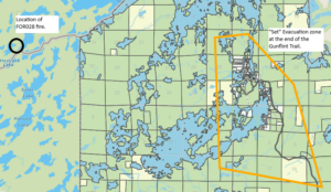
Location of Evacuation Zone ‘Set’ towards the end of the Gunflint Trail and proximity of the FOR028 wildfire
“Do final fireproof preparations for your house. Check in with your neighbors to make sure they are prepared as well. Start packing your vehicle and back your car into the driveway to ensure a quick exit. If you feel threatened, don’t wait for the final evacuation notice and just go,” the Sheriff’s Office said.
If residents decide to leave before a ‘GO’ activation, to please fill out this Emergency Evacuation Registration form below so authorities know you have left the evacuation zone.
Cook County uses the “Ready, Set, Go” method for emergency evacuations, here are the basics.
- READY for potential evacuation. Create an evacuation plan and be sure that all household members are familiar with the plan. Gather all emergency supplies and create an emergency supply kit. Be up to date with your insurance and take a video home inventory. Closely monitor the situation.
- SET to evacuate. Prepare to leave at a moment’s notice! Start packing your vehicle and back your car into the driveway to ensure quick and seamless evacuation. If you feel threatened don’t wait for a final evacuation notice, just go!
- GO! Evacuate immediately! Make sure all household members are accounted for. Have several predetermined evacuation routes planned and choose the safest one. Head to your designated safe location (relative’s house, motel, etc.). GO!
Emergency Evacuation Registration form
To limit calls into the Cook County dispatch center, please only use 911 if you have an emergency or see flames.
The Sheriff’s Office will continue to keep residents informed through it’s Facebook page and the Know Your Zone map located on the Cook County website.
Stay updated on Know Your Zone: https://cookcountymn.maps.arcgis.com/apps/webappviewer/index.html?id=2f0cb0740663455e9fe5c47b7fdb2379
Kalli Hawkins July 14, 2026