Additional BWCAW entry points and recreational sites reopen as wildfire conditions improve
The Superior National Forest is reopening additional portions of the Boundary Waters Canoe Area Wilderness (BWCAW) as wildfire activity has decreased and recent precipitation has helped moderate conditions.
The newly reopened entry points will allow both day-use and overnight BWCAW permits beginning July 30 and July 31, according to the U.S. Forest Service. The reopened areas include entry points in Cook, Lake and St. Louis counties.
In Cook County, the expanded reopening on July 31 will allow day-use on Seagull and Saganaga Lakes, at the end of the Gunflint Trail. Overnight trips remain closed through Aug. 3.
The Forest Service said the decision follows continued progress on wildfire suppression efforts and changing weather conditions.
The BWCAW was closed to all public access on July 14 after a series of lightning-caused wildfires spread across the Superior National Forest and into portions of the wilderness. The closure included overnight paddle, motor and hiking permits, as well as day use.
The Forest Service began a phased reopening process last week, first allowing limited day-use access at select entry points in Cook County on July 27. Overnight access returned to portions of the BWCAW on July 30, including about 39 percent of the wilderness area and roughly 41 entry points.
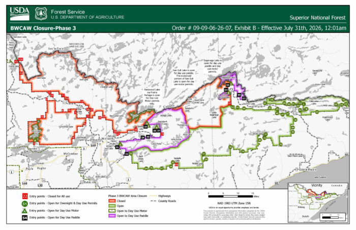
The latest reopening expands access to additional entry points listed in the Forest Service’s BWCAW Closure Order #09-09-06-26-07, including locations identified in updated closure maps and entry point lists.
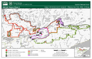
Map of BWCAW Phase 3 reopening with outlined day-use and motor use access at entry points | USFS
All entry points not included in the reopening documents will remain closed while multiple wildfires continue to burn in the region.
The Forest Service said it will continue working with local, state and federal partners to evaluate conditions and determine when additional areas can safely reopen. The agency said it expects to announce additional reopening updates later this week and will continue to coordinate closely with partners to determine when conditions are appropriate for reopening.
“Protecting the public and firefighters remains the Forest Service’s highest priority,” said the Forest Service.
The Forest Service is reminding visitors that reopened areas remain remote wilderness environments with inherent risks, including changing weather, limited access and potential wildfire activity.
Visitors planning BWCAW trips are encouraged to:
- Make a travel plan and share it with family or friends.
- Check current weather forecasts and wildfire conditions before entering the wilderness.
- Carry multiple forms of communication.
- Be prepared to be self-sufficient while traveling in a remote area.
- Review current BWCAW rules, regulations, and trip-planning information before departure.
For maps and more information on the Phase 3 partial reopening and fire restrictions please visit: https://fs.usda.gov/r09/superior/alerts
Find additional information here: https://www.fs.usda.gov/r09/superior/alerts/bwcaw-wildfire-area-closures
Additional Superior National Forest recreation sites reopen
In addition to areas of the BWCAW reopening, the Superior National Forest announced that 29 additional recreation sites in the western portion of the forest will reopen to the public beginning Friday, July 31.
The reopened sites include camping, boating, hiking, and other recreation areas within the Kawishiwi and LaCroix Ranger Districts. The sites had been closed since July 15 due to the July lightning wildfire incident.
The Forest Service said the reopening follows improved wildfire conditions and continued suppression efforts. Officials will continue to monitor fire activity and weather conditions as additional decisions are made regarding reopening other areas of the forest.
Campfire Restrictions
Portions of the Superior National Forest have moved from Class IV to Class III fire restrictions in developed and designated rustic recreation areas following recent rain. The Forest Service said the change in restriction status is in coordination with the Minnesota Department of Natural Resources, the Bois Forte Band of Chippewa, and Grand Portage Band of Lake Superior Chippewa.
All Boundary Waters Canoe Area Wilderness fire restrictions remain in place. Fire danger remains high, and the Forest Service encourages the public to exercise extreme caution.
Details and maps can be found on the Forest’s Alerts webpage: https://www.fs.usda.gov/r09/superior/alerts
Kalli Hawkins July 30, 2026