Heavy rainfall sweeps across the Northland, breaking daily November records
Areas across northern Minnesota received more than four inches of rain following several consecutive days of precipitation that began Sunday.
The weather system that brought substantial rain in Minnesota was part of a larger low-pressure system that moved across Colorado and the Southwest region of the U.S. several days earlier, causing historic flooding and widespread damage.
“It’s all connected,” said Ketzel Levens, a meteorologist with the National Weather Service in Duluth.
Rainfall reports across Cook County range from 1.74 inches to 3.5 inches from Nov. 1 through Nov. 4, according to data collected by volunteer CoCoRaHS observers.
WTIP weather reporter and contributor Mary Brislance said she recorded 4.5 inches of rainfall at her Lutsen home over three days. Another WTIP weather reporter and contributor near Poplar Lake in the mid-trail area of the Gunflint Trail recorded 4.5 inches of rain over 72 hours.
Areas across Lake County and St. Louis County also received significant rainfall.
According to CoCoRaHS data, 4.10 inches of rainfall was recorded in Two Harbors, and 3.71 inches north of Knife River between Sunday and Wednesday. Near Hibbing, reports range from 3.70 to 4.12 inches.
The National Weather Service in Duluth reported that several regions across the state, including Duluth, International Falls, Hibbing, and Brainerd, broke or tied daily record rainfall totals on Wednesday, Nov. 4.
On Nov. 4, Duluth tied an 1880 record for rainfall, receiving 1.02 inches. Farther north, International Falls broke a 2003 daily record for Nov. 4, receiving .69 inches of rain. Hibbing received 1.21 inches of rain on Wednesday, breaking a daily record of .68 inches in 1993.
The rainfall comes as the state is still experiencing drought conditions.
As of early November, areas along Minnesota’s North Shore are considered to have moderate drought conditions, while farther inland across the Superior National Forest and Boundary Waters Canoe Area Wilderness (BWCAW), conditions are considered to be abnormally dry, according to the Minnesota Department of Natural Resources drought monitor.
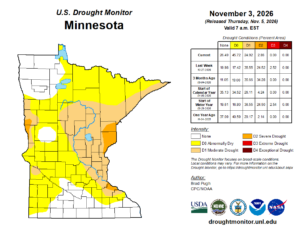
U.S. Drought Monitor graphic as of Nov. 3 | Minnesota DNR
Levens said rainfall over the past four days should likely help conditions across northern Minnesota, since the ground has not frozen yet.
“It will certainly help,” said Levens. “It’s especially helpful that this rain is coming at a time before the soils have frozen, so we can actually get some of that water into our soils, into our lakes, and then freeze it up.”
Levens said that while the rainfall will be beneficial in the short term, meteorologists will closely watch whether it has a long-lasting impact on lake levels and soil moisture in terms of drought conditions.
She said that this fall many Minnesota lakes have recorded low water levels. “Those lakes are feet below where they normally are, even this time of year when they tend to be at their sort of lower point.”
Kalli Hawkins November 5, 2026