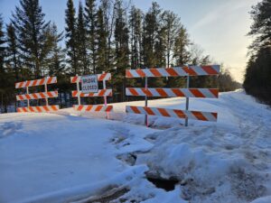
Highway Department explores designating The Grade as a county road
In the past two Cook County Board of Commissioners committee of the whole meetings, county officials have discussed county road jurisdictions and the potential for designating ‘The Grade’ as a county road.
On March 18, Cook County Highway Engineer Robbie Hass and Maintenance Superintendent Matt Nesheim presented a list of potential additions and removals to the county road system.
Proposed additions included a total of 25.6 miles, the majority consisting of a 23-mile stretch of Forest Service Rd 170, commonly known as ‘The Grade,’ stretching from Ball Club Rd to the Sawbill Trail. The U.S. Forest Service has historically managed The Grade as part of the Superior National Forest. While the Forest Service manages the road, the county has been plowing The Grade for numerous winters.
Hass said in the March 18 meeting that designating The Grade as a county road has been talked about for decades. “I think that alone illustrates its importance already.”
Commissioner Ann Sullivan spoke in favor of taking over the jurisdiction of The Grade from the Forest Service. Sullivan said The Grade is the county’s lifeline if Hwy 61 is closed due to a weather event, major accident, or natural disaster. “We have to keep The Grade open.”
Hass said the reliability of having The Grade open is of most importance.
The motivation to resume road jurisdiction conversations, particularly about The Grade, resulted from the ongoing disruption and closure of The Grade following the Cascade River Bridge project in the summer of 2024.
The Forest Service began construction on the Cascade River Bridge, but partway through the project, Forest Service officials said that additional design, resources, and time were needed to complete the project. The project was supposed to be completed in October 2024.
However, the road remains impassable due to the delays and may not reopen until September 2025.
“To have that kind of lifeline, that kind of redundancy for us completely cut off now and not even an option – I’m genuinely concerned for the next couple of months,” Hass said in the March 18 meeting.
The commissioners agreed to move forward with approaching the Forest Service to begin discussions about the potential road jurisdiction change. Hass said he would follow up with the Forest Service.
Earlier this week, on April 15, Hass and Nesheim returned to a committee of the whole meeting to share an update with the commissioners concerning discussions with the Forest Service.
After speaking with the Forest Service, Hass said they were open to the proposed road jurisdiction change.
“That doesn’t finalize anything. That just gets us to the next step,” Hass said in the meeting. “There’s still plenty of discussion for that, but you know we’re kinda moving in the ‘yup, we’ll do it’ category.”
To change the road jurisdiction, Hass said the Forest Service must go through the National Environmental Policy Act (NEPA) review process, collect any necessary right-of-way information, and do a center-line survey. The entire process is estimated to take six months to one year.
Commissioner Garry Gamble recommended Hass learn more about the legal process of transitioning a Forest Service road to a county road before returning to a Board of Commissioners to vote on the matter.
WTIP contacted the Forest Service regarding an update on The Grade bridge construction and about the potential jurisdiction transition of The Grade to a county road. The Forest Service responded but said they were unable to provide any additional information at this time.
While the Highway Department is exploring adding 25.6 miles to the county road system, Hass and Nesheim are also exploring removing 3.5 miles of roads and grassy driveways from the list.
The proposed road removals include Dyers Lake Rd, Ski Hill Rd, Charlie Lane/Anderson Rd, Trailsyde, Spruce Point, Nord Lof, Stonegate Rd, Ida Lane, and Ongstad Rd. Hass and Nesheim presented historical records about the various roads, including the year it was established as a county road, the mileage of the road, traffic count, and data showing homesteads vs. non-homestead properties.
Initially, Skyport Lane, which is not owned by the county, but is maintained by county was proposed to be removed from the list. However, after some discussion among the commissioners, the county will continue maintaining the road.
Discussions regarding the county road additions and removals will continue in the coming months.


