Little Knife Fire reaches 90% containment as crews prepare to hand management back to Superior National Forest
With recent precipitation and ongoing suppression efforts, firefighters have continued to make progress on the Little Knife Fire, with the wildfire now 90% contained. This week, wildfire management will transition from the National Incident Management Organization (NIMO) back to Superior National Forest officials.
“Firefighters are canoeing out of the wilderness Monday and preparing for demobilization, with management of the fire scheduled to return to the Superior National Forest on the evening of Aug. 4,” said the U.S. Forest Service on Monday. Over the past week, nearly two dozen hotshot crews and 13 smokejumpers were inserted on the ground on the eastern and southern edges of the Little Knife Fire to conduct suppression efforts.
As of Monday, the Little Knife Fire has burned an estimated 4,815 acres in the U.S. and has 132 personnel assigned. Following improved mapping of the area, the estimated size has decreased from the original estimate of 4,958 acres.
The fire originated in Ontario before crossing into the United States on July 15. Over the past several weeks, crews have worked in the remote wilderness, relying on canoes, helicopters and hand crews to suppress the fire while minimizing impacts within the federally designated wilderness.
A large portion of the Little Knife Fire continues to burn in Canada. The latest estimate of the fire’s size was approximately 80,000 acres.
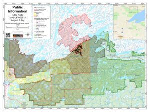
Map of Little Knife Fire as of August 3 | Superior National Forest
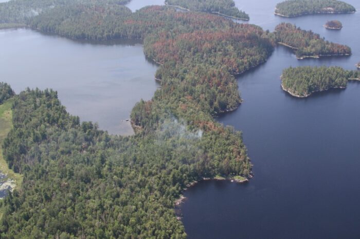
Little Knife Fire – mosaic burn pattern July 25, 2026 | Photo by USFS
Further west, across the Superior National Forest and the Boundary Waters Canoe Area Wilderness, conditions and containment of several other wildfires have also improved.
Among the larger fires, the Bear Trap Fire, which is 40% contained, has burned 37,885 total acres, nearly 30,000 of which are in the U.S. Forest Service officials said firefighters continue scouting opportunities for direct containment near Stuart Lake while reinforcing secondary containment lines along the Echo Trail and Angleworm Trail.
The Thumb Fire has grown to 17,327 total acres, the majority of which is in the U.S. As of Monday, the fire is 57% contained. Fire managers reported that fire behavior has increased during the past several days. Crews are being inserted near Loon Lake to begin constructing containment lines along the fire’s southwest corner between Slim Lake and Fat Lake.
Outside the Boundary Waters, firefighters continue making progress on several large wildfires burning in the Superior National Forest.
The Camp Fire north of Winton is estimated at 4,357 acres and is 69% contained. Firefighters continue monitoring smoke between Pipestone Bay and Back Bay while looking for opportunities to strengthen containment near Jackfish Bay.
The Sioux Fire, located north of the Echo Trail east of Jeanette Campground, remains at 7,071 acres and is 16% contained. Crews are constructing containment lines along the fire’s northern edge while working to fully contain portions that crossed south of the Echo Trail.
The Wolfpack Fire, located north of the Echo Trail east of Loon Lake, is estimated at 5,751 acres and is now 25% contained. Firefighters are accessing remote sections of the fire by canoe and on foot to build containment lines.
Over a dozen of the wildfires throughout the Superior National Forest and BWCAW that resulted in closures and evacuation orders began from a lightning strike incident on July 6.
A new lightning-caused wildfire, the Finstad Fire near Buyck, was detected Aug. 1. The fire remains approximately one-tenth of an acre and is being managed with aerial suppression.
Fire managers said changing weather conditions could influence fire behavior Monday. Winds from the south and southeast are expected to increase to around 25 mph, potentially reigniting hot spots and producing additional smoke. A cold front is forecast to move into the region overnight, shifting winds to the northwest and bringing a chance of thunderstorms that could produce up to one-quarter inch of rain and wind gusts up to 35 mph.
Officials continue to ask the public to respect all closures, evacuation orders, and fire restrictions. Residents can check the latest evacuation information through interactive maps maintained by Cook, Lake and St. Louis counties, as evacuation zones continue to change based on fire activity and suppression progress.
The Superior National Forest has also eased some fire restrictions. Portions of the forest have moved from Class IV to Class III restrictions, allowing campfires once again in developed recreation sites and designated rustic campgrounds, provided fires are built only within Forest Service fire rings. Additional recreation sites have also reopened as conditions improve, although visitors are encouraged to check the Superior National Forest’s online alerts before traveling.
Although the Little Knife Fire is nearing full containment, officials emphasize that wildfire season is not over. With several large fires still burning across northeastern Minnesota and weather conditions that can rapidly change fire behavior, firefighters continue to ask residents and visitors to remain vigilant and follow all fire restrictions and closures while suppression efforts continue.
Kalli Hawkins August 3, 2026