Wildfire burning in the BWCA near the end of the Gunflint Trail
There is a wildfire burning in the Boundary Waters Canoe Area Wilderness near the end of the Gunflint Trail.
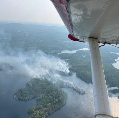
The fire, known as the Spice Lake Fire, was approximately 30-acres in size as of 11 p.m. last night, according to the U.S. Forest Service. The fire is burning between Spice Lake and Ogishkemuncie Lake, southwest of Seagull Lake.
A closure area in the Boundary Waters is likely in the immediate vicinity near the fire. This could include closing campsites on Ogishkemuncie and the lone campsite on Spice Lake. There could also be a temporary quota reduction for some of the entry points in this area. The Forest Service said any closure area could be significantly larger than just the immediate area where the fire is currently active. The reason the closure area needs to be larger than the active fire zone is because of the length of time it takes for people to paddle and portage from lake to lake if they needed to safely get away from the fire, the Forest Service told WTIP June 14.
The news of the fire comes on the same day a campfire ban was announced for the BWCA and most of Superior National Forest. The campfire ban goes into effect today (June 14).
The cause of the fire has not been determined.
An aircraft flight took place yesterday over the fire for a size up of the fire’s activity and location. Another flight was scheduled for this morning to get an update on the fire. Active and moderate fire activity was witnessed in a mixed Boreal forest with aspen, pine, and balsam fir trees. There is also evidence of spruce budworm affected trees which means dead down and standing trees which can cause active fire behavior, according to the Forest Service.
Fire personnel located BWCA paddlers and canoe campers on the area lakes and made contact with several groups on Ogishkemuncie Lake, the Forest Service reports. The paddler groups were directed off the lake last night as a safety precaution.
Fire personnel will fly over the fire again this morning and are developing a fire suppression plan. Additionally, staff will begin working on a public safety plan for the area to ensure public visitors remain safe.
There is heavy smoke across most of the WTIP listening area this morning. Most of the smoke is from wildfires that continue to burn in Canada, according to the National Weather Service.
Spice Lake is located east of Knife and Kekekabic Lakes and southwest of Seagull Lake and approximately 10 miles west of the Gunflint Trail.
WTIP’s Joe Friedrichs spoke with Tim Engrav, a public information officer for the Forest Service on Superior National Forest, about the Spice Lake Fire. The interview aired live on WTIP at approximately 7:30 a.m. Wednesday, June 14. Audio below.


