Spring snowstorm may bring 10 inches along North Shore in back-to-back systems
A wintry storm is expected to arrive across northeastern Minnesota and the North Shore starting Wednesday evening, April 1.
The storm’s arrival is unfortunately not an April Fool’s joke from Mother Nature.
“It’s definitely looking like we’re going to need those shovels and snowblowers still here as we head into late week and into the weekend,” said Bryan Howell, a meteorologist with the National Weather Service in Duluth.
The winter system will consist of “back-to-back systems,” Howell said. Snow totals for the North Shore range from 6 to 10 inches.
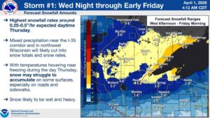
Storm #1 Forecast Snowfall Amounts | National Weather Service
The first system will arrive on Wednesday night and continue through the morning of April 3.
“So this is kind of like a little appetizer for what’s coming up later in the week,” Howell said.
There will be a slight break on Friday before the second system arrives Friday night through Saturday evening, Howell said. The highest snowfall accumulation is expected during the second system, according to the National Weather Service. A winter storm warning is in effect from April 2 at 1 a.m. to April 3 at 7 a.m.
“Those look like they could give us some pretty significant snowfall, especially along the North Shore,” Howell said.
High winds are expected to accompany the mixed winter precipitation, with gusts up to 40 mph on Thursday.
The arrival of a winter storm during the first few days of April feels like Groundhog Day for many North Shore residents, as a significant storm arrived on April Fool’s Day in April 2025.
WTIP’s Steph Vos spoke with Bryan Howell with the National Weather Service in Duluth about the upcoming winter storm. Audio below.
WTIP will speak with the National Weather Service again on Thursday, April 2, at 8:40 a.m. on North Shore Morning. Tune in to 90.7 FM or stream at wtip.org.
Kalli Hawkins April 1, 2026