Cook County officials urge Gunflint Trail residents to prepare as Canadian wildfire burns near border
As wildfire activity continues across northeastern Minnesota and just north of the U.S.-Canada border, Cook County officials are urging residents and property owners to be prepared.
An approximately 2,000-acre wildfire, called FOR028, is burning on the Canadian side of Ottertrack and Knife lakes along the U.S.-Canada border.
The wildfire produced a visible smoke plume Sunday that could be seen from the Seagull Lake area, approximately 10 miles away, towards the end of the Gunflint Trail. The fire has grown from approximately 23 acres to nearly 2,000 over the weekend, according to the Ontario Ministry of Natural Resources.
On Sunday evening, the Cook County Sheriff’s Office placed an area near the end of the Gunflint Trail under a “Ready” evacuation designation on the county’s ‘Know Your Zone’ website as a precaution should the wildfire cross the U.S.-Canada border.
“We want to make sure that residents are aware that this fire is not too far away from the end of the trail,” said Cook County Sheriff Ben Hallberg.
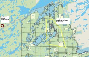
‘Ready’ Evacuation zone towards end of Gunflint Trail | Graphic by Know Your Zone
Ready means that residents should be prepared for a potential evacuation. Residents should create an evacuation plan and ensure that all household members are familiar with it. County officials recommend gathering all emergency supplies and creating a ‘Go Bag’ or emergency supply kit.
Federal, state, and county officials are monitoring the wildfire daily with aerial flights.
Forest Service officials said they are in communication with counterparts at Quetico Provincial Park and are “working closely with Cook County officials on taking the proper precautions.” The Forest Service plans to deploy firefighters to conduct suppression operations if the fire crosses over into the U.S.
Hallberg said that residents near the end of the Gunflint Trail should take the initiative to prepare their properties, develop a plan, and stay alert to messages from authorities.
“The biggest concern is looking at the weather starting Tuesday,” Hallberg said. “I think the wind changes direction and could push it to the U.S. side. It’s being monitored.”
Tuesday is expected to bring critical fire weather across northeast Minnesota. The National Weather Service is forecasting low relative humidity, very hot temperatures, and a strong north wind.
“These conditions could lead to rapid spread of wildfires,” the National Weather Service in Duluth said.
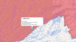
Location of FOR028 wildfire | Graphic by Ontario Ministry of Natural Resources
A step that property owners up the Gunflint Trail can take as a precaution is to operate a sprinkler system.
“Keeping everything green around the buildings leading up to a potential fire gives you a huge advantage should that happen,” said Ruth Wagner, a member of the Gunflint Trail Volunteer Fire Department and owner of Golden Eagle Lodge.
Wagner said property owners can run the sprinkler system for an hour or more to douse the surrounding area near structures. Another step is to remove any vegetative brush near the home.
Within the Gunflint Trail Fire Department, volunteer firefighters are continuing to monitor conditions and prepare for a potential wildfire.
“We’re ready,” Wagner said. “So if something does blow up, we’re here.”
Wagner said that despite the nearby Canadian wildfire, the campfire bans throughout the Superior National Forest and, more recently, the temporary closure of the Boundary Waters Canoe Area Wilderness, business is “as usual” at Golden Eagle Lodge.
“Obviously, that can change, and we’re going to do our best on both fronts to keep the public up to date on that,” Wagner said.
Wagner added, “I don’t want to instill a sense of panic or anything because we’re not at that point yet. But if we do get there, the more prepared you are, the better this is going to go for everybody.”
Several other Canadian wildfires are burning within Quetico Provincial Park, the largest being FOR015, at approximately 4,300 acres. Smoke from Canadian wildfires, likely mixed with smoke from wildfires burning across the Superior National Forest, blanketed Grand Marais on Sunday evening. Conditions improved on Monday, but county officials are warning of poor air quality conditions starting Tuesday.
A link to the Know Your Zone evacuation zones is below:
More information about wildfires is below:
Superior National Forest website https://www.fs.usda.gov/r09/superior/alerts
Minnesota Incident Command System website at www.mnics.org
For statewide fire restriction information: https://mnics.org
WTIP’s Kalli Hawkins spoke with Cook County Sheriff Ben Hallberg on Monday about the latest on the wildfire near the U.S.-Canada border and what Cook County residents should know.
WTIP’s Kalli Hawkins also spoke with Ruth Wagner of the Gunflint Trail Volunteer Fire Department and an owner of Golden Eagle Lodge up the Gunflint Trail about steps homeowners and cabin owners can take, such as running sprinkler systems to help reduce wildfire risk and better prepare their properties. Audio of both interviews is below.
Kalli Hawkins July 13, 2026