Heat wave continues as air quality concerns grow
Extreme heat is expected to continue through Tuesday evening, with temperatures remaining in the 90s across much of Cook County. At the same time, cooling Lake Superior waters and the potential for worsening air quality are creating a unique mix of conditions along the North Shore.
“Humidity is going to be pretty high up there too. We’re looking at dew points getting into the low 60s,” Cory Rothstein, a meteorologist with the National Weather Service in Duluth, told WTIP. “So the combination of those two should be pushing heat index values into the mid to upper 90s as well for inland areas.”
Cook County released a list of cooler, well-ventilated, or air-conditioned public spaces for residents to go if their homes become too warm:
- Grand Marais Public Library, 104 2nd Avenue West
- Cook County YMCA, 105 5th Street. Access may depend on membership or facility policies.
- The Grand Marias Hub, 10 N Broadway Ave, Grand Marais, MN 55604
- Other cool, well-ventilated, or air-conditioned public buildings and businesses that are open to the public
The county reminded individuals that heat exhaustion can cause heavy sweating, headache, nausea, dizziness, weakness, and thirst. Residents should move to a cooler location, drink fluids, and cool the body if symptoms develop.
Meanwhile, an upwelling event in Lake Superior is expected to bring colder water temperatures to parts of the shoreline. Grand Marais experienced periods of significant fog Monday and Tuesday morning.
With wildfires burning across the Superior National Forest and along the U.S.-Canada border, Cook County residents should also prepare for potentially deteriorating air quality.
“We could see an air quality alert as early as tomorrow depending on wind conditions and stability of air mass,” said Nicholas Petrack with the U.S. Forest Service.
The National Weather Service issued an air quality alert in effect as of 7 a.m. Tuesday until 11 a.m. on Thursday. Heavy smoke from several large wildfires across northeast Minnesota and Canada will move south behind a frontal boundary across the region Tuesday.
“Additional round of heavy smoke are possible across the region,” the National Weather Service said.
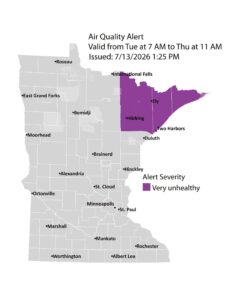
Minnesota Pollution Control Agency issued an air quality alert due to wildfire smoke July 14-July 16 | Graphic by MPCA
Residents can monitor current air quality conditions and forecasts through AirNow.gov.
The Minnesota Department of Natural Resources has also issued a Red Flag Warning for Tuesday, July 14, due to the combination of hot temperatures, dry fuels and fire-weather conditions.
Temperatures are expected to moderate later this week. Rothstein said there is a 50% to 70% chance of precipitation Friday.
“Still a little bit of question as to how much rain we might get with that, given the pattern that we’re in right now,” Rothstein said. “But that’s looking like our next chance of seeing any sort of appreciable precipitation.”
Rothstein spoke with Tracy Benson on Monday’s edition of “North Shore Morning.” Audio of that conversation is available below.
Josh Hinke July 14, 2026